(To open book, flip the book corner)
ACKNOWLEDGMENTS
I wish to express my grateful thanks to all those who helped in the preparation of this book, and in particular to Mr. T. B. Barnes, Rector, Royal College, for having given me the pleasant task of writing it and for his advice in the early stages, to Mr. W. E. F. Ward, C.M.G., for valuable criticisms of the text and maps, to Dr. R. E. Vaughan for permission to make use of and adapt Map 5, to Mr. S. Pelte for similar help in Map 8, and to Mr. Thiboudois, Public Works Department, for having drawn the map of Rodriguez. The historical notes in Chapter V are culled from "The History of Mauritius" by kind permission of the authors, Messrs. Barnwell and Toussaint. I have based Map No. 1 on the Admiralty charts of the Indian Ocean and the various maps of the island on the Ordnance Survey Map of Mauritius.
R. H. A.
4A SCHOOL GEOGRAPHY OF MAURITIUS
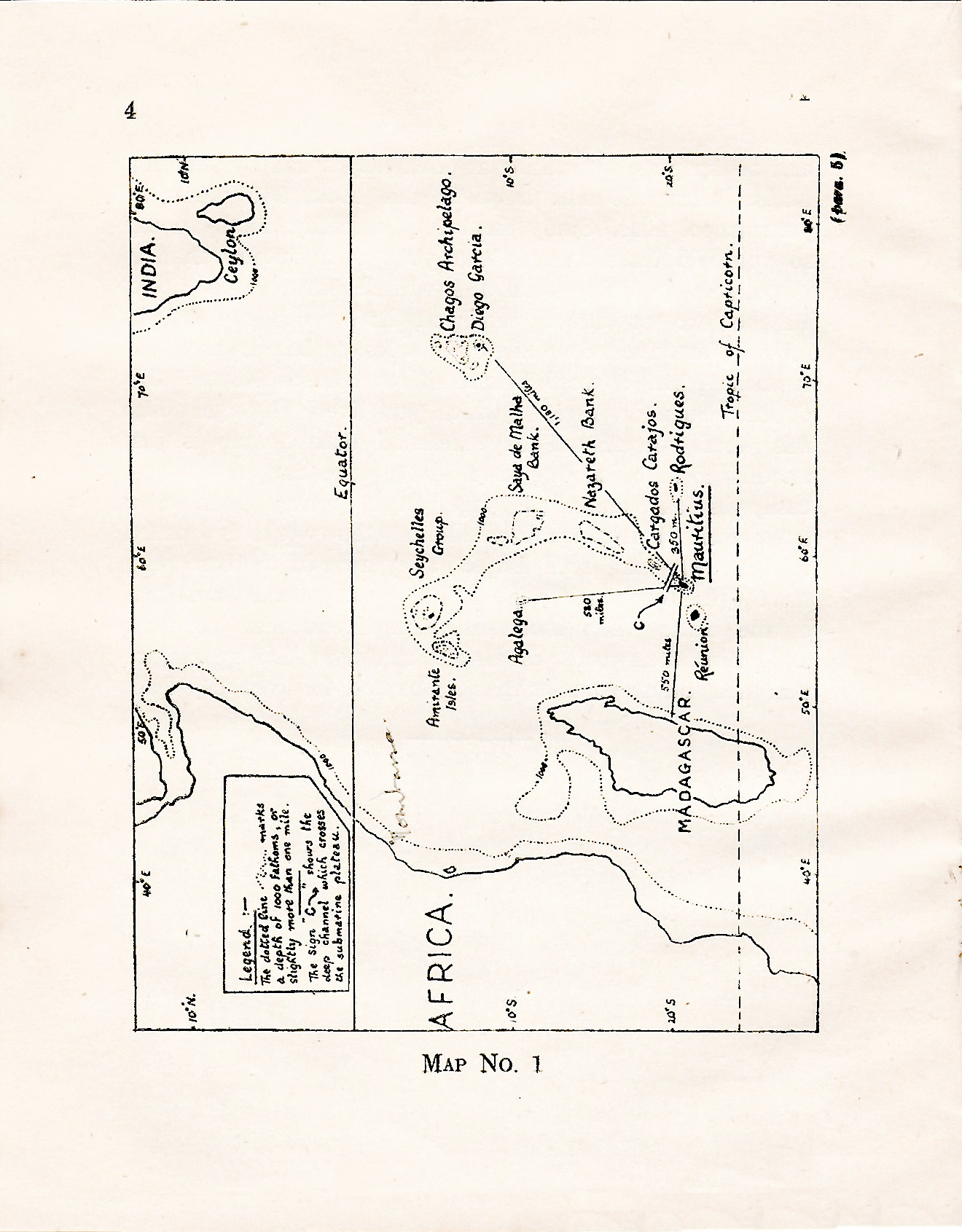
5CONTENTS
TEXT
| CHAPTER ONE YOUR OWN DISTRICT |
0 |
| CHAPTER TWO YOUR ISLAND |
8 |
| CHAPTER THREE THE CLIMATE OF OUR ISLAND |
39 |
| CHAPTER FOUR FORESTRY, AGRICULTURE AND OTHER INDUSTRIES |
52 |
| CHAPTER FIVE PEOPLE, PLACES AND COMMUNICATIONS |
73 |
| CHAPTER SIX OTHER ISLANDS UNDER OUR CONTROL |
93 |
| CHAPTER SEVEN LOOKING OUTWARDS |
103 |
6
MAPS
| No. | TITLE | PAGE |
|---|---|---|
| 1 | The position of Mauritius in the Indian Ocean | 7 |
| 2 | Mauritius—plains, plateaux and mountains | 22 |
| 3 | The slope of the land in our island | 27 |
| 4 | Mauritius—mountain ranges, rivers, reservoirs and canals | 37 |
| 5 | Mauritius—Crown forests, pas géométriques, scrub and thickets, and cultivated land | 54 |
| POPULATION DIAGRAM : Indo-Mauritian and General Population | 74 | |
| 6 | Mauritius—towns and villages, roads and railways | 79 |
| 7 | Rodriguez | 95 |
| 8 | Agaléga, Diégo Garcia and St. Brandon | 100 |
| 9 | Cable and Steamship Routes serving Mauritius | 107 |
7
CHAPTER ONE
YOUR OWN DISTRICT
1. We live on one of the most beautiful islands in the world. Men have named it "The Star and Key of the Indian Ocean" and "The Land of Rainbows, Waterfalls and Shooting Stars." The first of these names was given to our Island about a century ago. Mauritius is a "key" to the Indian Ocean. this means that the nation which holds Mauritius can command the sea routes between India, South Africa and Australia. A hundred and fifty years ago, French raiders, or Corsairs as they were called, used Mauritius as a base from which to attack British ships sailing between India and the0
The reason for the second name is clear. In this land of sunshine and showers, rainbows are1
2. To read is not enough. It is much more important to use your eyes, and to see the things that are about you. Most of us look at things, but do2
3. Study your own district. The better you know it, the easier it will be to understand the rest of the world, because then you may compare things you see and3
4. As it may not be4
6
 7
7CHAPTER TWO
YOUR ISLAND
5. Study carefully Map No. 1 on the opposite page. It shows the position of your island in the Indian Ocean. Mauritius is about 1,250 miles from the east coast of Africa. A fast ship can go from Port Louis to Durban in five days. Between Mauritius and South Africa lies the great island of MADAGASCAR. If our Island was ever joined to Madagascar or to Africa it must have been a long time ago. Men have found that the sea which lies between is more than three-and-a-half miles deep in places. 8
6. The distribution of land and water on the earth's surface has not always remained unchanged. When the earth was still very young there was a vast continent South of the Equator. Students of geography have given it the name of GONDWANALAND. South America, Africa, India and Australia all formed part of it. As time went on the land rose in some places and sank in others. Big pieces of land broke off and floated away from the parent continent. The Atlantic and Indian Oceans were born. In those early days Madagascar was still joined to Africa, but during another movement of the land it was separated from Africa by the Mozambique9
7. At another stage in the history of the world, probably later, Mauritius was formed by the action of volcanoes. The sea between Mauritius and Madagascar is very deep. When these islands were discovered by explorers, they notice that there were many animals and plants in Madagascar which were not to be found in Mauritius. What is stranger still, there were birds in Mauritius which did not exist anywhere else in the world. For these and other10
8. Look again at Map No. 1. You will see that Mauritius lies at the south end of a dotted line which has Seychelles at its north end. Along this line the sea is one mile deep. Inside it, most of the sea is less than one-eighth of a mile deep. Outside it, the ocean is between two and three miles deep. This means that there is a big plateau, one thousand two hundred miles long, rising from the bottom of the sea. In some places the plateau appears above the sea. These places are shown on the map as the Amirante Isles, the Seychelles, Saya de Malha Bank, Nazareth Bank,11
9. This study of the ocean shows two things. First, that a very long time ago Mauritius probably was at the end of a great island, bigger than Madagascar. Second, that probably our island was never joined to Madagascar or to Africa by a land bridge.12
10. South-west of us is our younger sister-island, LA REUNION. When the air is clear, in the late afternoon, it is possible to see it from the Trou aux Cerfs near Curepipe. Réunion is bigger than Mauritius. Its greatest length is forty-five miles and its greatest breadth thirty-two miles. Its coast is rocky and dangerous. From a narrow coastal plain the land rises quickly to a great height. Some of its plateaux13
11. The word "volcano" has already appeared a number of times. Do you know what volcanoes are, and how they are formed ? A very long time ago the earth was part of the sun. When it broke away it was very hot, but it gradually cooled, became solid and grew smaller in size. The outside cooled15
12. When the lava breaks through the surface of the earth, a new volcano is born. It may happen on dry land, or16
13. Violent eruptions cause solid rock as well as lava to be flung into the air. The smaller pieces of rock are known as CINDERS or VOLCANIC ASH, the larger pieces as BOULDERS. When liquid lava is thrown high in the air, it may become solid as it falls. It forms round or oval drops which are known as VOLCANIC BOMBS. Such "bombs" can be found in the sides of the railway cutting at Pailles. You can see volcanic ash and boulders at Souillac, Tamarin and other parts of the island.
14. Volcanoes, like earthquakes and cyclones, are often dangerous to human beings but, unlike the other two, they build up as well as destroy.18
15. It should be clear to you by now that Mauritius has been formed by the work of volcanoes. Perhaps you have seen some of the dead craters. The easiest to visit is the Trou aux Cerfs, close to Curepipe. Others are the Trou Kanaka, Grand Bassin, and Bassin Blanc. Many of our mountains rise from the plain,19
16. In Mauritius the volcanoes were not active all the time, nor is it likely that they were all active at the same time. There were long periods of rest. The land slowly became covered with vegetation. Then there were fresh eruptions, the lava flowed again and buried the burning trees. The last lava to flow became very hard when it cooled. You may see it at Plaine des Roches. It makes a great winding path across the district of20
17. Around the coast there are more than twenty small islands. Including these, the area of Mauritius is seven hundred and twenty square miles ; almost two-thirds of the size of Réunion. Coral reefs surround the island, except for a stretch of eight miles along the south-east coast from Souillac to Ilôt Brocus, where there are low cliffs. 21
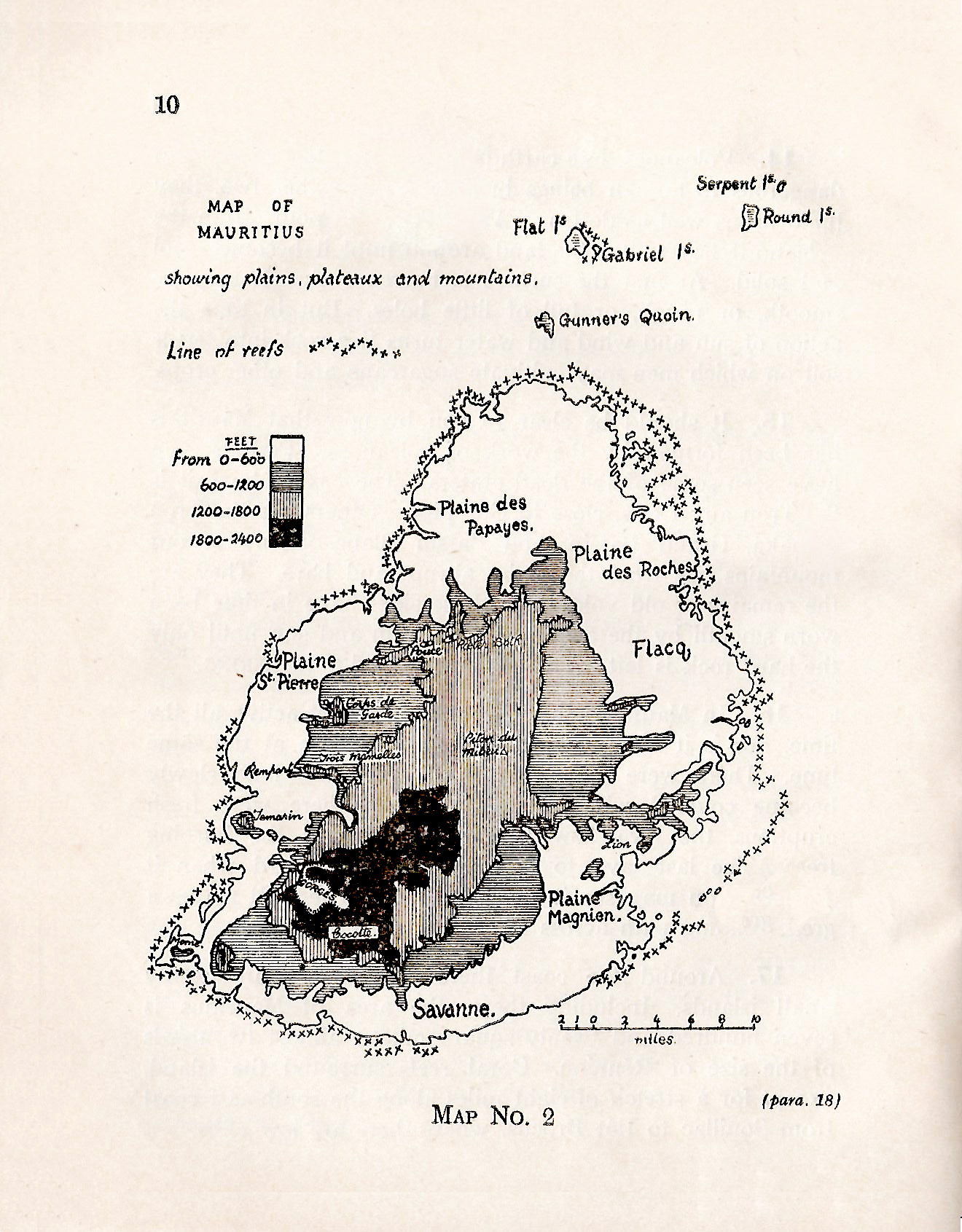 22
2218. Have you ever stopped to consider how coral reefs are formed ? Turn to Map No. 2, and you will see that the coral reef around Mauritius closely follows the shape of the coast-line. Unless this has happened by chance, there must be an explanation. Coral reefs are built by tiny animals who, instead of moving about like most other animals, rest upon the coral which they have produced from their bodies. Living coral is soft and jelly-like, and becomes hard only when the animal that makes it dies. These tiny animals are delicate creatures and die easily if conditions do not exactly suit them. For instance, they cannot live out of23
19. Coral reefs are not all exactly like those we find around Mauritius. There are three main types - the FRINGING REEF, which is found close to the shores of an island ; the BARRIER REEF, which is much further away from the shore (sometimes as much as a hundred and fifty miles away) ; and the CORAL ATOLL, which is a circular reef surrounding a lagoon. Mauritius possesses a fringing reef. The best example of the second type is the Great Barrier Reef which for more than one thousand miles borders the eastern coastline of Australia. Diégo Garcia, the principal island in the Chagos Group, is an example of a coral atoll. It happens to25
 27
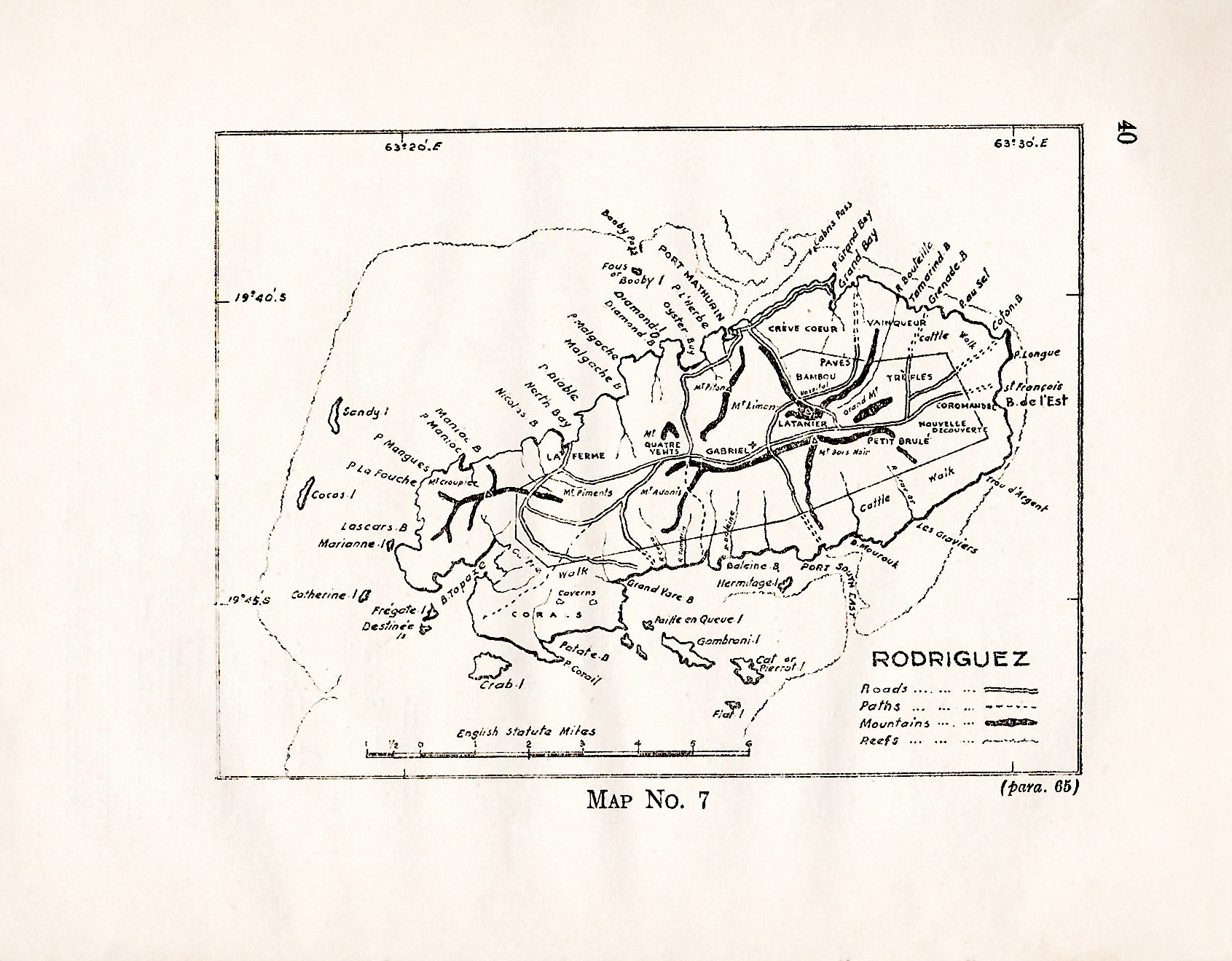
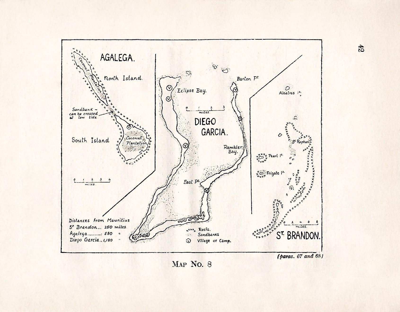
2720. Turn once more to Map No. 2 and study it carefully along with Map No. 3. With the aid of your teacher and of what you already know of the island, you should be able to read these two maps correctly. They show you that the land rises from the coastal plains to a central plateau, gradually in some places, more steeply in others. This central plateau covers most of the districts of Moka and Plaines Wilhems, and is highest towards the south, in the area around Curepipe and Plaine Champagne. The coastal plains are widest in the north and east of the island, but near Vieux Grand Port and in the south-west corner the mountains come28
21. Map No. 4 shows the principal rivers. If all our rivers were shown the map would have been too crowded. The two longest are Grand River South-East (24½ miles) and Rivière du Poste (15 miles). Most of the rivers rush down steep ravines. When much rain has fallen they quickly become raging torrents. After a cyclone or a heavy fall of rain the sea is coloured reddish-brown by the earth carried off by the rivers. Sometimes bridges are broken by the force of the water. But when the season is dry, the rivers are little more than tiny streams.30
22. Perhaps you have noticed that most of the rivers in Mauritius flow through deep channels. The rivers did not find these channels ready made for them ; they carved them gradually out of the land. Our rivers are short and fast flowing because the slope from the central plateau to the sea is so steep. The faster a river flows the more quickly does it wear away its channel. This wearing away is done not only by the water, but also by the solid material carried by it on its journey to the sea. The material consists of small rocks, pebbles and sand carried in the water and of larger rocks rolled along the bed of the river by the31
23. The river bed is not worn away at the same rate throughout the whole length of the river, because in some places it consists of hard rock, in others of soft rock or soil. Soil is washed away more quickly than soft rock, and soft rock more quickly than hard rock. This is the reason why waterfalls are formed. The hard rock resists while the softer rock beyond it is being gradually worn away, leaving a hole into which the river drops. In time the hard rock also is bitten into by the river which now flows through the gorge or ravine thus formed.
24. This cutting away of the land is called the32
25. The Cascade des Galets, south of Mare-aux-Vacoas is the greatest of the many waterfalls we have in Mauritius. The water drops 500 feet. Not far away, close to Souillac, is a remarkable cascade, called the Rochester Falls. The rocks, formed in columns, rise like the steps cut in a33
26. There are only two natural lakes in Mauritius, Grand Bassin and Bassin Blanc. Both are in the craters of extinct volcanoes, and are in the highest part of the Central Plateau. There are also three man-made34
 37
3727. Mare-aux-Vacoas also provides drinking water for the town of Plaines Wilhems, supplies part of the needs of Port Louis, and delivers water to the Tamarin Falls hydroelectric power station which produces electricity for Curepipe, Vacoas and the neighbouring district. The main domestic water supply for Port Louis comes from the Grand River North-West. It passes through two covered surface reservoirs which between them can hold two million gallons of water.
38
CHAPTER THREE
THE CLIMATE OF OUR ISLAND
28. Climate plays a most important part in the lives which people live. It influences their health and happiness, their food, houses and clothing, their means of transport. In some parts of the world life is a continual struggle against the cold ; in other parts heat is as great a menace. The most fortunate people are those who live in temperate climates where it is neither too hot nor too cold to work and play. In such places, where people can lead fully active lives, the great civilisations of the world have developed. Have you ever wondered why the peoples of Europe and39
29. Fortunately, our climate is sufficiently varied to give most of us enough energy to lead active lives. If we40
30. In addition to these daily local breezes, there are also steady sea breezes called the SOUTH-EAST TRADES which blow for about ten months of the year. That is the second reason why our climate is better than one usually finds in the tropics. Before the steamship was invented, the lives and the livelihood of sailors depended42
31. For part of our summer the south-east trades are less strong and may die away for a few days at a time. During this part of the year a hot damp wind, called the MALGACHE43
32. It cannot truly be said that there is a dry season and a wet season in Mauritius, for it rains throughout the year, but the summer months from December to April are usually the wettest. A summer morning is usually calm, with a clear blue sky. The air is fresh, and there is plenty of vivid colour in the cane fields, forests and mountains. Then clouds begin to form, and in the early afternoon heavy rains drench the countryside. After an hour or two they cease and the sun appears again. The rain which falls in these conditions is called CONVECTIONAL RAIN.44
33. Air can carry a certain amount of water in the form of water vapour. This is why clothes that have been washed are hung out to dry. If the air is damp the clothes may take a long time to dry, because the air is carrying almost its full load of moisture. Warm air can hold more moisture than cold air. In the summer the land becomes very hot some hours after sunrise. The air above it is heated and rises, carrying its moisture with it. As it rises it becomes cooler and less able to carry the same load. The water vapour is changed into a cloud of rain45
34. The south-east trades first strike the east and south-east coasts of the island before beginning their climb over the central plateau. After their long journey across the ocean they are full of moisture. As they climb they become colder and drop46
35. Cyclones often cause much damage to our island. We can expect them to come during the summer months from December to May. We have had cyclones, however, in every month of the year except August and September. Records have been kept of the47
36. Another bad cyclone hit the island in 1931. It lasted for49
37. Occasionally the island suffers almost as greatly from lack of rain. At the beginning of this century there was a drought which lasted for fourteen months, from November 1899 until December 1900. The cane fields and vegetable gardens suffered considerably. In 1934 and again in 1939, severe droughts reduced the sugar crop by one-quarter. But droughts are less dangerous than cyclones, for water can be stored in reservoirs, but high winds cannot be prevented from blowing down trees and houses and uprooting the crops.
51
CHAPTER FOUR
FORESTRY, AGRICULTURE, AND OTHER INDUSTRIES
38. Two hundred years ago almost all the island was covered with indigenous (native) forests, "so dense that a person could with difficulty read in them at noon." A glance at Map No. 5 will show how little remains. Notice that the shaded area, showing Crown forests, is almost the same as the area of mountains and central plateau shown on Map No. 4. In their search for ebony the Dutch began the destruction of the forests. Later, under French rule, more areas were cleared so that crops might be grown. The great French Governor, Mahé de Labourdonnais,52
 54
5439. The forests are now controlled by the Forest Department. Part of its duties is to preserve the indigenous trees and scrub in the central plateau, as they help to store rainwater. Mountain forests at cooler, higher altitudes hold water like a sponge. They delivery this water gradually to the nearby lowlands. If the forests are destroyed the rain flows away almost as quickly as it falls on the ground, and much of it is lost as flood-water which is carried off in an hour or two by the rivers. What is yet more serious is that if the trees are destroyed the rains quickly wash away the soil and leave only bare rock. The careless55
40. The chief industry of the island is the production of sugar. Four-fifths of the cultivated land is covered with cane, from which at present more than three hundred thousand tons of sugar is made each year unless a cyclone or a drought affects the crop. Although the Dutch brought cane here, the real credit is due to Labourdonnais. He caused the58
41. There are a number of reasons why this has happened. It costs more to run three hundred small factories than thirty big ones. It is easier to transport canes to the mill now that we have estate tramways, than it used to be when we had only59
While these improvements were being made in the factories, there was also much progress in the fields. Better varieties of sugarcane were planted. Some of these new canes were brought from other sugar-producing countries. Others were discovered by the Department of60
From the molasses left in the making of sugar a lot of alcohol is made. There are61
42. Over a century ago, in 1817, the first English Governor of Mauritius, Sir Robert Farquhar, encouraged the cultivation of tea in Mauritius. He had a small tea garden at Le Réduit. Unfortunately, when he left Mauritius no one took an interest in his scheme and the plantation was abandoned. Nearly seventy years later Sir John Pope Hennessy62
43. Another industry is the making of bags, mats and ropes from the fibre of the aloe plant. The sugar estates alone need about four million sacks each year. At Quatre Bornes a big factory is now64
44. Bananas are widely grown and form an important item of food for the population.
45. One of our Governors, Sir Hesketh Bell, did much65
46. In 1760 La Compagnie des Indes began to make salt in Mauritius from sea water. On a journey from Black River to the Morne you will see a number of salt pans between the road and the sea. Notice that the pans are at different heights. Water is pumped from the sea into the highest pan, and66
47. At low tide coral is gathered from the reefs. This is put in a limekiln (four-à-chaux) where it is burned to make lime. One of the best limekilns is at GRAND PORT, just outside Mahébourg. Quicklime (la chaux67
48. There are many other small industries in Mauritius. In Port Louis there are two match factories, several engineering works for making and repairing the machinery used in sugar factories, a small ship-building yard, a factory for making coconut68
49. You may think, after reading these paragraphs, that Mauritius can produce all it needs, but this is far from being true. Think for a moment of the hundreds of things we use which come to us from other countries―clothes, shoes and foodstuffs, railway engines, buses, lorries and cars from Great Britain ; cotton goods, rice and dholl from India ; rice and teak from Burma ; flour from Australia ; motor cars and petrol from the United States ; edible oil from Ceylon ; beef from Madagascar and copra from the Seychelles. Go into any shop in70
50. At present our sugar crop provides the money to buy all these things. If it fails us, we face disaster. It is not wise to depend so greatly on a single crop. Sometimes, of course, a country has no choice but to depend on a single crop, but if you have understood what you have read in this chapter, you will see that Mauritius can have other valuable industries if it is prepared to develop those already started and to create new ones. Each SECONDARY industry may not by itself employ many workers or produce a lot of goods, but the total effect of such industries71
72
CHAPTER FIVE
PEOPLE, PLACES AND COMMUNICATIONS
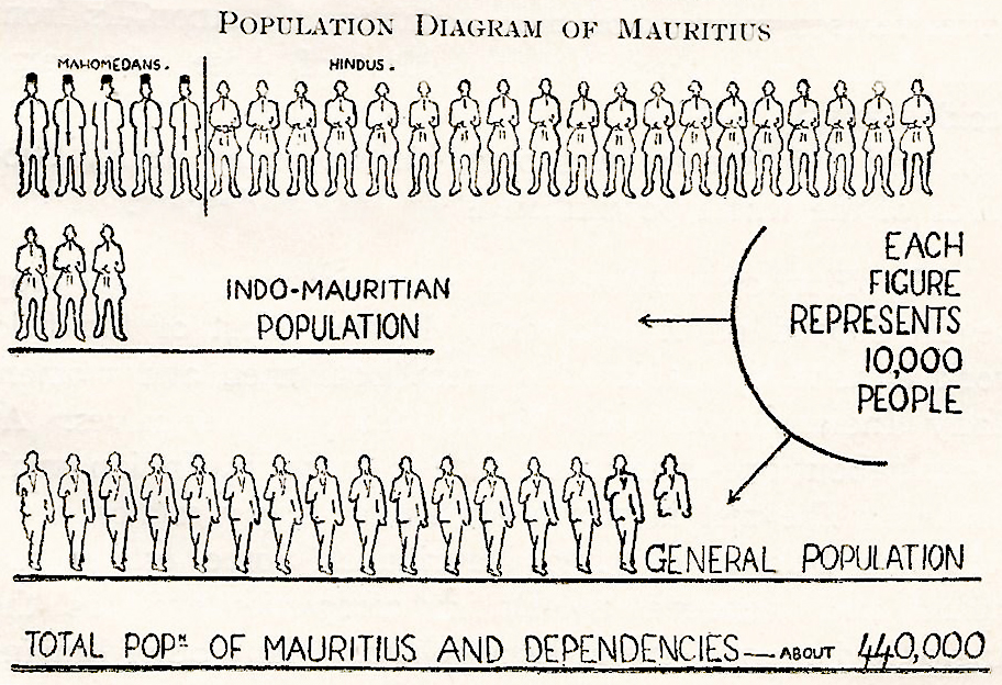
51. on this small island slightly more than four hundred and twenty-five thousand people live. This makes Mauritius one of the most crowded places on the earth. Look at the picture on this page. Each figure represents ten thousand people. Count the number of figures which you find under the title "Indo-Mauritians," and then work out how many people there are in this part of the population. What is the number of Mahomedans? How many Indians of other religions are there? The "General Population" is made up of white Mauritians, coloured Mauritians and 73
52. In your History classes you will hear in detail how this island was populated. Here it is sufficient to mention briefly that in two centuries the population has 74
53. How do we live ? As sugar is our principal crop we all depend on it to a large degree. Most of the field work is done by Indian76
 79
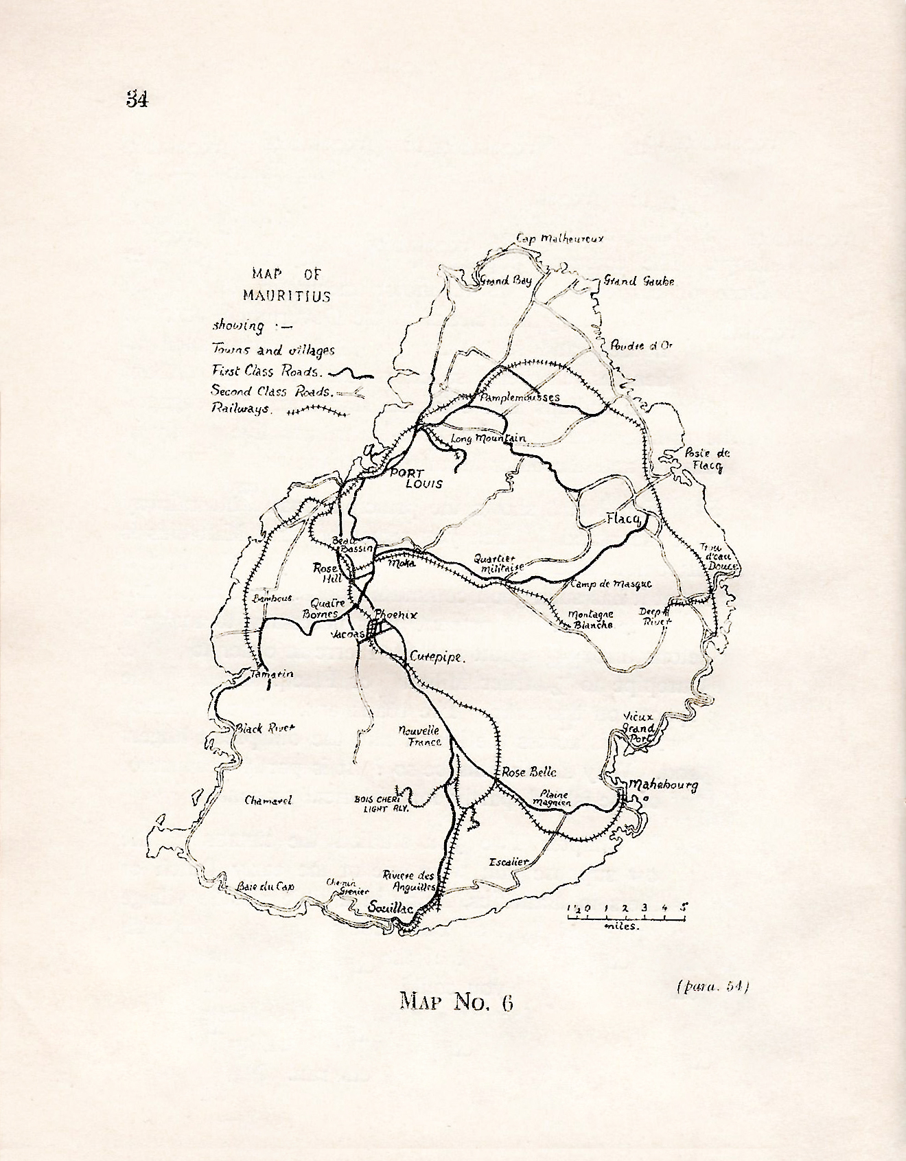
7954. Map No.6 shows the principal road and railway routes of the island. When you remember that Mauritius is a small remote island in the Indian Ocean, you should feel proud that it has such good communications. But much still remains to be done. At present it is necessary to make a long detour through Réduit and St. Pierre in order to travel from Curepipe to Quartier Militaire or Flacq. Look at the blank spaces on this map. The roads and railways stretch from Port Louis across the island like the outspread fingers of a hand. Why should this be so ? It is partly because of the relief of the island, partly for historical reasons.80
55. In Chapter Two you studied the RELIEF of the island. Now suppose you were one of the early Dutch or French settlers in Mauritius, living in a little seaside village at Flacq or Grand Port or Port Louis. In order to visit your friends in another part of the island you could either sail around the coast or you could walk. Roads did not yet exist, only narrow footpaths through the forests which covered most of the island. There were no bridges over the deep ravines through which the rivers ran. No roads, no bridges, no trains nor motor cars! In such conditions you would probably choose the easiest path to follow between any two81
56. That is the way in which the relief of the island influenced our communications. But the events of history have also played a part. The south-east trades brought the early explorers to the eastern part of the island, and there two towns grew up, Vieux Grand Port which was the seat of both Dutch and early French rule and Flacq which was the centre of the valuable ebony trade. But Grand Port had certain disadvantages. The three entrances to the harbour were exposed to the full force of the trade winds which often blow hard for weeks on end. Inside the harbour there are reefs and shoals. When83
57. Most of the remaining towns and villages are younger than Grand Port, Flacq and Port Louis. Mahébourg was founded by Decaen only five years before the British conquered Mauritius. Souillac, which receives its name from the Vicomte de Souillac, is about twenty-five years older than Mahébourg. Many villages were founded by freed slaves after the year 1835. Two of these are Phoenix and Grand Gaube. In the year 1858 there were only two hundred people living in Curepipe. Within the next thirty years the number had increased to twelve thousand. Curepipe's rapid growth took place at the expense of Port Louis. In 1865 malaria85
58. Mauritius is not an "old country" like England or France or India. Most of its history has taken place in the last two centuries. Many of you live in villages or on estate camps which are not much older than the oldest living person in your neighbourhood. Try to find out the story of your own village from your parents or grandparents. It is surely an interesting story and possibly an exciting one also.
59. To many of you there is nothing strange about a railway train.87
60. There are also many miles of light railways on the sugar estates for the transport of the sugarcane from the fields to the factories. This work used to be done by carts drawn by oxen and mules until the year 1903 when nearly all the animals died from a disease called surra. The estates were then forced to build light railways.
61. Mauritius is not an easy country in which to operate railways. In the short distance from Port Louis to Curepipe the trains have to climb a height of89
62. In addition to rail transport there is also a good system of road transport. A large number of motor buses carry passengers on all the main roads, especially between Curepipe and Port Louis. There are also many private 90
91
Note to paragraph 59:
The total length of 164 miles of Government Railway is made up of -
(a) 106¼ miles of main line railway.
(b) 13⅔ miles of Bois Chéri Light Railway
(c) 28 miles of Station lay-out.
(d) 16¼ miles of Sidings.
92
CHAPTER SIX
OTHER ISLANDS UNDER OUR CONTROL
63. Look once more at Map No. 1 which shows the position of Mauritius in the Indian Ocean. It also bears the names of other islands or groups of islands. Some of these are our DEPENDENCIES. This means that they are under the control of the Government of Mauritius. Some of them are rented by trading companies in Port Louis. They send men to work on these islands or to catch fish nearby.
64. The names of these dependencies are:
RODRIGUEZ,
CHAGOS ARCHIPELAGO,
AGALEGA,
CARGADOS CARAJOS GROUP. 93
In 1944, the population of Rodriguez was counted and found to be eleven thousand, eight hundred and eighty-five. There were only one thousand five hundred and seventy-eight people living in the other three dependencies in the same year.
THE SEYCHELLES GROUP used to be a dependency of Mauritius, but in 1903 it became a separate colony. 94
 95
9565. Rodriguez, the principal dependency of Mauritius, is nine and a half miles long and four and a half miles broad. This volcanic island is three hundred and fifty miles away in an easterly direction. From the sea the island, which is surrounded by a coral reef, seems to be a single mountain mass. The capital, Port Mathurin, is a village of over six hundred people on the northern shore. It has no harbour, but ships can rest in safety close by as they are sheltered by the land mass from the prevailing winds. The inhabitants of Rodriguez are chiefly farmers. For their own use they grow maize, manioc and sweet potatoes. To make96
66. The CHAGOS ARCHIPELAGO, sometimes called the97
67. Find AGALEGA on Map No. 1. It is five hundred and eighty miles north of us. It is about twelve miles long and five miles wide and is divided into two parts by a sand bank which can be crossed at low tide. You can see this clearly in Map No. 8 which also shows the shape of Diégo Garcia and St. Brandon. The island is one big coconut plantation. From coconuts copra is made and sent here to be manufactured into coconut oil and soap. Horses are99
 100
10068. The last of the dependencies of Mauritius named in paragraph 64 is the CARGADOS CARAJOS GROUP. The principal island is ST. BRANDON which is two hundred and fifty miles north of us. All the islands of this group are small and are only a few feet above the sea. About one hundred men live on them and work for a Mauritian fishing company. They return regularly to their homes here. Fish abound in the shallow waters that surround this group of islands. Our main problem is to get the fish to Mauritius in sufficient quantity and at a low price. For that, a ship with cold storage space is required. At present the fish is dried and101
102
CHAPTER SEVEN
LOOKING OUTWARDS
69. We are in touch with the rest of the world in three ways. These are by RADIO, by CABLE, and by STEAMSHIP. Most of you have listened on a wireless set to music or news coming from London, Paris, Bombay and other cities. Or perhaps you listen to the daily programmes of the Mauritius Broadcasting Service. People in Réunion, Madagascar and South Africa can also listen to them. There are other radio stations in Mauritius for sending and receiving messages in morse code. So today we can have news within a few hours of happenings in distant parts of the world. We can even listen to103
70. Do you know what a telephone is ? Perhaps you have been on one side of the road or the railway a number of wires carried on poles. Along these wires you may send messages by the aid of a machine called a TELEPHONE. Thus, you may speak from Rose Hill to a friend who is in Curepipe. If you do not wish to telephone you may write your message on a piece of paper and give it to a man in the Post Office. He will use104
 107
10771. The heavy black lines on the Map show the British steamship routes which are useful to us. The sugar we send to England may be carried there by two routes. One way is along the east coast of Africa into the Red Sea, through the Suez Canal and so to England. A longer route is by Durban and Capetown into the Atlantic Ocean. The journey to England takes between a month and six weeks by sea. Mauritius is also joined to Ceylon and India by British steamship routes. Find these on the map. Ships of other nations also come here. French ships come from Marseilles through the Suez Canal to Madagascar. After they have called at several108
72. Today the Atlantic Ocean is being daily crossed in a few hours. One can travel from Australia to England in five days and sleep in a hotel every night. A fast mail service between these two countries takes only forty-eight hours. The aeroplane has made this possible. At present there are hundreds of air routes across the world and each year new routes are being opened. Great progress was109
At this time one of the Empire air routes ran from Great110
73. In 1869 a great Frenchman, Ferdinand de Lesseps (whose wife was a Mauritian), constructed the Suez Canal which opened a new route to India and China. The Canal runs from the Gulf of Suez, at the northern end of the Red Sea, to Port Saïd on the Mediterranean coast. It is one hundred miles111
To Mauritius the opening of the Suez Canal was a severe blow. Before 1869 ships en route for India and the Far East had to pass around the Cape, and many of them called at112
74. Mauritius is more than the island home of over four hundred and twenty-five thousand people. It is part of the world-wide British Empire, and as such has its part in keeping open the communications of the Empire. In time of war the importance of our island increases, as ships from Mauritius can protect113
114